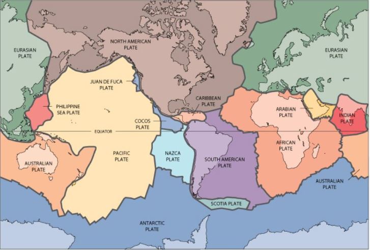
Australia lies within the Indo-Australian tectonic plate, which is a thin and significantly fractured mass of rock moving northwards towards the tectonic plates of Eurasia, the Philippines, the Pacific, India and Africa, where it experiences high compressive stress by colliding and rubbing against the adjacent rock masses (see figure 3). This collision and rubbing between these two tectonic plates builds up pressure and once the accumulated pressure exceeds the strength of the two rock masses, the two tectonic plates of the fault slide past one another and release violent energy and seismic waves, which is the cause of intraplate earthquakes experienced across Australia (Wilson, J, Lam, N & Pham, L 2008). Fortunately, Australia is a country of low to moderate seismic activity with earthquakes in the country only having magnitude 6.8 or lower (SA History Hub 2018).
Of the states, South Australia has had ten low magnitude earthquakes occur with the majority of them occurring in the Flinders Ranges, Mount Lofty Ranges and occasionally in the Eyre Peninsula (SA History Hub 2018). The epicentres of these earthquakes are scattered across the state and do not occur along the known fault lines. The earthquakes that occur in the state are small with a magnitude of 6.5 or lower and would rarely be felt in seismically active regions of the world but due to Australia’s shallow depth and low attenuation of vibrations in South Australia, such earthquakes are frequently noticed by seismologist and the public (SA History Hub 2018).
FAULTS WITHIN SOUTH AUSTRALIA
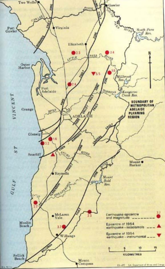
The main faults within the Adelaide Region mainly stem from a westerly direction and travel north-east away from the ocean and toward the mainland. The major faults within the Adelaide Region include the Willunga Fault, the Claredon Fault, the Crafers fault, the Eden-Burnside fault, the Para fault, the Hope Valley Fault, the Redbank Fault and the Alma Fault (see figure 2). Not all of these faults are visible and the visibility of these faults is due to the geological structure of the region that the fault is located in (see figure 3). This geological structure can indicate the risk level of damage to the area as lose soil in the region will move more readily than solid rock and will cause more damage to the area.

GEOLOGICAL STRUCTURE SURROUNDING SOUTH AUSTRALIA’S FAULT LINES
Willunga Fault: The Willunga fault is surrounded by silt, sand, gravel, quartzite, dolomite, calcrete, sandy clay and limestone.
Clarendon Fault: The Clarendon fault is surrounded by iron, cemented bedrock, buff sandstone, alluvial sandstone clay and green silt stone.
Crafers Fault: The Crafers fault is surrounded by siltstone, quartzite, dolomite, gneiss and schist.
Para Fault: The Para Fault is surrounded by alluvial and fluvial sand clay and gravel, calcrete, estuarine deposits, siltstone, quartzite and dolomite.
Hope Valley Fault: The Hope Valley Fault is surrounded by sandy clay, gravel, marl and limestone, marine sediments, limestone, dolomite, and granitic gneiss.
Redbank Fault: The Redbank Fault is surrounded by sandy clay with gravel, estuarine deposits off the coast.
Alma Fault: The Alma Fault is surrounded by siltstone, quartzite, dolomite, sandy clay with gravel.
PAST EARTHQUAKE ACTIVITY IN SOUTH AUSTRALIA
The first of these nine earthquakes occurred in Beachport 1897. The earthquake at Beachport is the largest to have occurred in South Australia. It caused massive damage in the South East of the state at Kingston, Robe and Beachport (see figures 4 and 5), and even caused minor damage in Adelaide. Near the epicentre there were several known cases of liquefaction and its thought that the epicentre was offshore (Department of State Development 2014).

The second earthquake occurred in Warooka 1954 and had magnitude 6.0. This earthquake caused severe damage on the Yorke Peninsula but did not cause any damage near Adelaide (see figure 6). It was originally thought that the epicentre was at Warooka, but recent work suggests that it was actually in St Vincent Gulf. Unlike the Beachport earthquake, no liquefaction was reported, however, this event caused two deaths and were first known death from an earthquake in Australia (Department of State Development 2014).

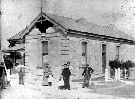
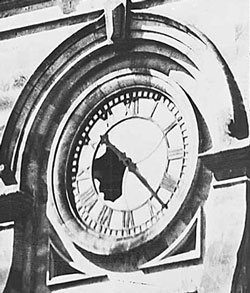
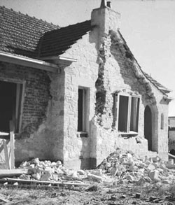
The most infamous earthquake to occur in South Australia, actually occurred in Adelaide in 1954. This earthquake had a magnitude 5.5 and occurred in the early hours of the morning, demolishing a few buildings in the Darlington area (see figures 7, 8 and 9). Wide-spread cracking was reported but not surface rupture was found and it was believed by seismologist that earthquake must have occurred on the Eden-Burnside fault at a fairly shallow depth (Department of State Development 2014).

South Australia’s lowest magnitude earthquake occurred in Hawthorndene 2015. The earthquake had magnitude 1.7 and only noticed by a few people in the Adelaide Hills Area due to being about 10 kilometres deep with an uncertainty of 2 kilometres (Department of State Development 2014).

